Published On Jul 20, 2023
The Mapbox Snowflake native application currently supports forward and reverse geocoding using the Mapbox APIs, as well as Mapbox Enterprise Boundaries point-in-polygon lookup.
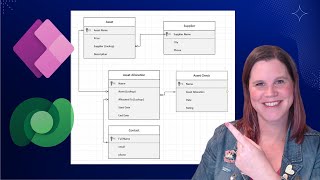
This video demonstrates boundaries lookup using the Mapbox Snowflake native app. Boundaries lookup is a stored procedure which takes point geometries from your data (as longitude and latitude coordinates) and returns geometries and metadata for boundaries that a point falls within. You can look up countries, provinces/states, postal codes, political districts, and more.
You'll learn how to:
- Prepare a table for use with the boundary lookup stored procedure call
- Execute the call
- Parse the JSON results to extract only the boundary information you need
Geocoding is used by companies for a variety of purposes, including asset tracking, supply chain and retail strategy, and analysis of demographic trends, elections, and real estate.
Part 1: Batch Geocoding in Snowflake with the Mapbox Native App: • Batch Geocoding in Snowflake with the...
Part 2: Reverse Geocoding in Snowflake with the Mapbox Native App: • Reverse Geocoding in Snowflake with t...
Mapbox Snowflake native app resources:
- Mapbox Snowflake native app Marketplace listing: https://app.snowflake.com/marketplace...
- Mapbox Snowflake native app QuickStart tutorial: https://quickstarts.snowflake.com/gui...
- Mapbox Snowflake native app Blog Post: / geocoding-address-data-with-the-mapbox-sno...
Other Mapbox resources:
- Mapbox Geocoding API Documentation: https://docs.mapbox.com/api/search/ge...
- Mapbox Developers Discord Server: / discord
- Mapbox Website: https://mapbox.com