Published On Oct 19, 2023
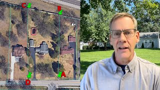
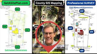
In this video, I will provide an in-depth analysis of how to find your property lines and conduct an experiment to determine which satellite imaging service (LandGlide, Google Earth Parlay 2.0, or County GIS) will provide users with the most accurate longitude and latitude coordinates when compared to their actual property corners.
I will teach viewers how to use satellite imaging to find their own longitude and latitude coordinates and then how to find those coordinates out in the real world once they have them.
We will then test which satellite imaging service (LandGlide, Google Earth Parlay 2.0, or County GIS) gives the highest degree of accuracy when using these tools to locate the property lines of any home. To determine which is the most reliable.
Disclaimer: If you are buying/selling land/property ALWAYS hire and pay a land surveyor to get them exact. This video is meant to aid land buyers and neighbors with minor property disputes. Smiles from here.😊
What I used in this video:
1. LandGlide: https://landglide.com/
2. Google Earth: https://earth.google.com/web/
3. Property Line / Parcel Data: https://reportallusa.com/solutions/pa...
4. Coordinate / GPS Formatter: https://apps.apple.com/us/app/coordin...
5. Garmin GPS-MAP 65* (Hand Held-Outdoor): https://www.garmin.com/en-US/p/715085
For other videos in this series:
How To Find Property Lines (Version 2)
• How To Find The Property Lines Of Any...
How To Find Property Lines (Version 3)
• How to Find the Property Lines of Any...