Published On Sep 25, 2023
In this video, we'll show you how to easily go from drone photos to a survey-grade topographic surface using the Terrain Creator and Virtual Surveyor apps. Follow these key steps:
1) Setup.
Create a new project, import drone photos, and choose your desired survey coordinate system. You can set the horizontal system and the vertical reference. Review your images and remove any unwanted drone photos from your project.
2) Add Ground points.
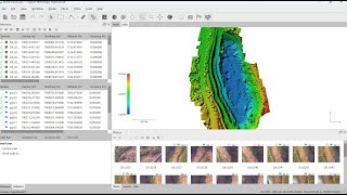
To enhance the initial accuracy of your model, add ground control points. Marking ground control points becomes a breeze with Terrain Creator's guided process. Terrain creator will propose the candidates. You mark the point through a click and use the space bar to navigate to the next candidate. The model automatically improves as you mark more points.
3) Processing.
After marking your ground points, start the photo processing. When processing is finished the orthomosaic and Digital Elevation Model (DSM) are loaded automatically. Ground control point errors are conveniently displayed.
4) Go to Virtual Surveyor.
Move your results to Virtual Surveyor through a single-click. Perform a check point analysis before starting your real survey work.
5) Create a Topographic Surface.
With your project in Virtual Surveyor, you can create a topographic surface at bare earth level. Define a boundary, run a low-pass grid, and triangulate your data. The resulting topographic surface follows the ground level accurately. Display the surface as contours and export to CAD.
Start your free trial on https://www.virtual-surveyor.com!