Published On Jul 7, 2021
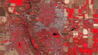
Application of remote sensing and satellites for agriculture are expanding fast during past few years. The major advantage of satellite data compared to other precision agriculture methods is universal availability of such data - whether or not the farmers take advantage of that. In this video, we illustrated the changes of Normalized Difference Vegetation Index (NDVI) in a wheat and canola farm in Saskatchewan, Canada over 6 years. The performance of the farm was investigated as an average and was compared to segmented subplots.
Although extracting insight from each subplot of the farm is overwhelming for the human mind, artificial intelligence models can digest and extract hidden patterns out of that. Grain Data Solutions feed historical values from satellite imagery and use artificial intelligence and time series analysis to predict performance of farms as whole, or on the subplots as small as pixel size in satellite image.
(music: bensound)